Hurricane Humberto likely to bring dangerous surf to most of East Coast this week. Maps show its forecast path.
Hurricane Humberto is likely to bring dangerous surf to most of the U.S. East Coast and Bermuda this week, the Miami-based National Hurricane Center said, adding that tropical storm conditions are possible in Bermuda Tuesday.
The swells will likely cause “life-threatening surf and rip current conditions,” the center warned.
Humberto rapidly strengthened over the weekend, reaching Category 5 strength on Saturday before fluctuating back down to a still-powerful Category 4 on Sunday.
The storm is one of two systems swirling over the western Atlantic. The other one strengthened into Tropical Storm Imelda on Sunday and is forecast to become a hurricane but move away from the southeastern U.S.
Hurricane Humberto forecast and path
Humberto’s center on Monday morning was about 340 miles south-southwest of Bermuda. It was moving northwest at about 13 mph with maximum sustained winds of 145 mph, making it a Category 4 hurricane, according to the Hurricane Center.
The center of Humberto is forecast to pass west and then north of Bermuda on Tuesday and Wednesday.
CBS News 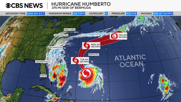
“Fluctuations in intensity are possible today. Gradual weakening is forecast after that, but Humberto is expected to remain a dangerous major hurricane into Tuesday,” the hurricane center said.
A tropical storm watch is in effect for Bermuda. In addition, “swells generated by Humberto will continue to affect portions of the northern Leeward Islands, the Virgin Islands, Puerto Rico and Bermuda through much of this week,” forecasters at the hurricane center warned.
People along the U.S. East Coast could also begin to see the effects of Humberto beginning Monday, with the potential for life-threatening surf and rip currents.
Humberto is the eighth named storm of the 2025 Atlantic hurricane season. It came on the heels of Hurricane Gabrielle, which wasn’t impacting land as it headed farther out into the Atlantic.
Forecasters also tracking Imelda
The hurricane center is also closely monitoring a second storm system over the northeast Caribbean in the Atlantic, which strengthened into Tropical Storm Imelda on Sunday and is expected to become a hurricane Tuesday.
NOAA / National Hurricane Center 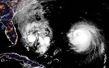
Imelda was expected to bring “significant rainfall” to portions of Cuba and the Bahamas, the hurricane center said. It will also likely produce flash and urban flooding, with the possibility of mudslides in higher terrain across eastern Cuba.
CBS News 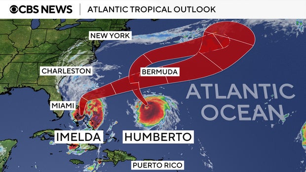
There was also a possibility it could interact with Humberto — a phenomenon known as the Fujiwhara effect, in which two different storms converge and either join or spin around each other. But CBS News meteorologist Nikki Nolan said such an outcome is not considered likely in this case.